Whakaari/White Island continues to emit low levels of volcanic gas and steam accompanied by hydrothermal activity. The Volcanic Alert Level remains at Level 2.
Recent flights over Whakaari/White Island to measure gas emissions and observe surface activity showed continued hydrothermal activity, including minor geysering. Low to moderate gas and steam emissions continue. There is no evidence of any volcanic eruptions, and the overall activity remains low. The Volcanic Alert Level remains at level 2.
Our latest airborne gas measurements from 26 March 2024 showed Sulphur Dioxide (SO2) levels increased marginally compared to the previous measurements a month prior (29 February 2024). Over the past twelve months there has been a slight upward trend of SO2 emissions but, overall, emissions of the three key gas species we monitor, Carbon Dioxide (CO2), Hydrogen Sulphide (H2S), and SO2, remain within the low to moderate range.
Images taken during an observation flight on 20 March 2024 showed minor geysering in parts of the crater area, caused by the continuous emission of steam and gas (grey areas in Figure 1) through muddy pools. The emitted gases also form sulphur and other salt deposits (yellow and white areas in Figure 1). The grey and green colours of the pools and the lake are mainly a result of dissolved sulphur combined with suspended sediments. These hydrothermal phenomena are typical for Whakaari/White Island. Steam and gas plumes are sometimes visible above the island from the coast, especially when the air is cool and relatively calm.
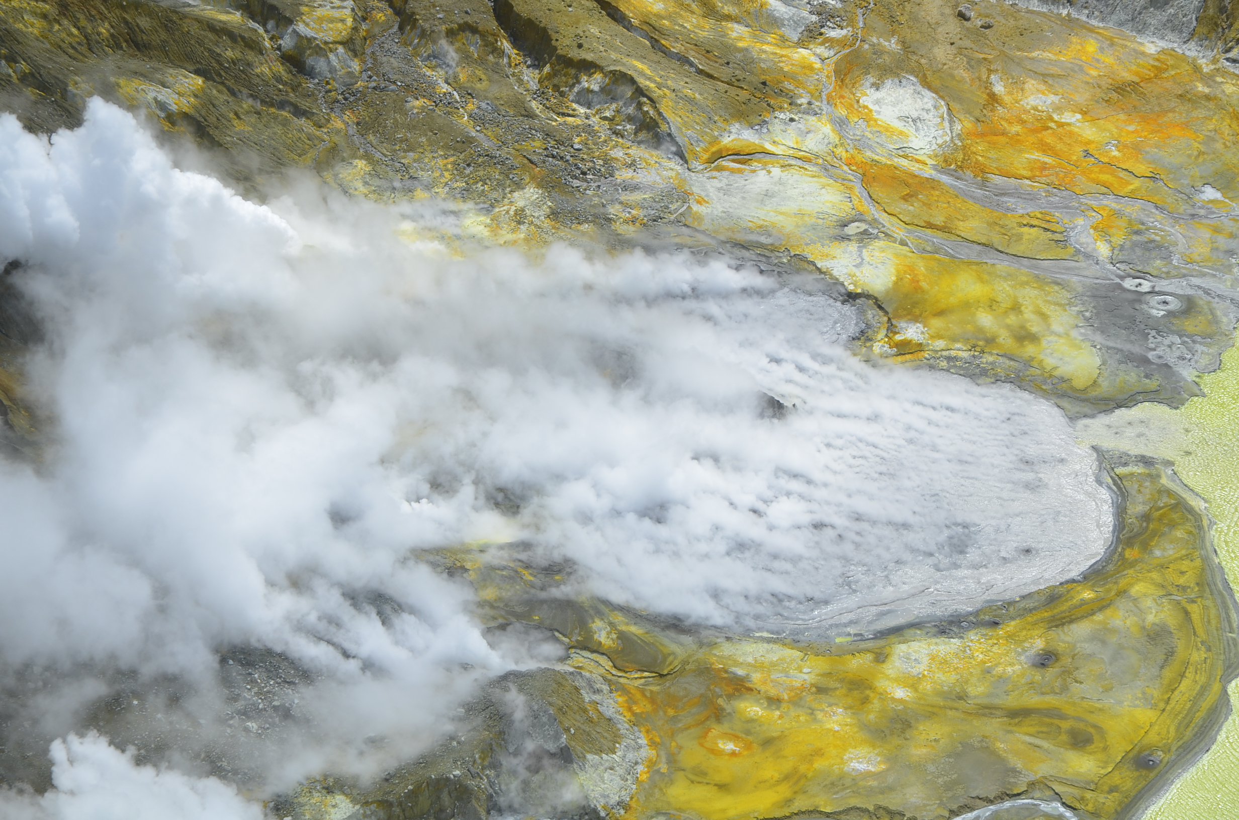
Figure 1: Aerial view of Whakaari/White Island, 20 March 2024 showing grey coloured pool in 2019 Crater (centre) with geysering. Photograph credit: Brad Scott, GNS Science.
Whilst we are currently unable to monitor the island in real-time with instrumentation on the ground, we continue to make observation and gas measurement flights every few weeks to monitor overall level of activity of the volcano. These are complemented by satellite-based ground deformation data approximately every 10 days, allowing us to monitor ground deformation trends. Daily satellite-based SO2 emission measurements complement our more sensitive but less frequent gas measurement flights. Neither of these satellite techniques have detected significant changes in the overall activity at the volcano over the past few months.
The Volcanic Alert Level remains at Level 2 (moderate to heightened unrest) and the Aviation Colour Code remains at Yellow, acknowledging the current level of activity, but also continuing to consider the greater level of uncertainty in our interpretation due to the current lack of consistent, usable real-time data.
The Volcanic Alert Level reflects the current level of volcanic unrest or activity and is not a forecast of future activity. While Volcanic Alert Level 2 is mostly associated with volcanic unrest hazards (including discharge of steam and hot volcanic gases, earthquakes, landslides, and hydrothermal activity), potential for eruption hazards also exists and eruptions can still occur with little or no warning.
Further information about the Volcanic Alert Levels and what they mean can be found here.
GNS Science’s National Geohazards Monitoring Centre and Volcano Monitoring Group, through the GeoNet programme, continue to monitor Whakaari/White Island for further changes in unrest.
Duty Volcanologist: Yannik Behr
Media contact: 021 574541 or media@gns.cri.nz