A look at Raoul Island volcano
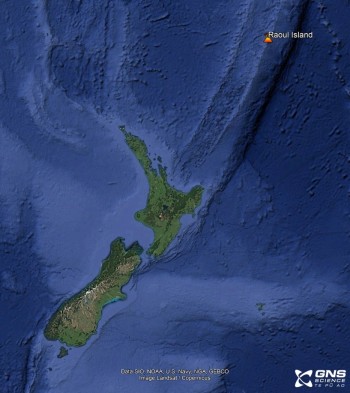
Lying approximately 1100 km northeast of Auckland, in the Kermadec Islands, is Raoul Island, the summit of a large active volcano. It is an important geohazard monitoring station for New Zealand and other Pacific nations, well positioned to detect and measure local Kermadec earthquakes and provide us essential insight into the size and arrival-time of tsunami waves.
Located in the subtropical Kermadec Islands, Raoul Island is renowned for its pōhutukawa forest and bird life. Mana whenua Ngāti Kuri call this Island Rangitāhua, and it is sometimes also referred to as Sunday Island.
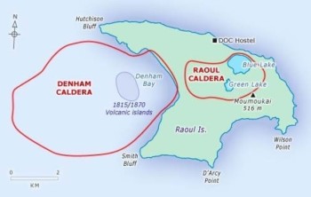
The anvil-shaped island marks the summit of a large, mostly submerged volcano, that has two caldera craters formed largely by subsidence immediately after large eruptions.
Raoul Island is the largest island in the Kermadec Islands. Today the floor of the onshore Raoul Caldera is occupied by two crater lakes, while Denham Bay caldera is flooded by the ocean.
How we monitor the volcano
Raoul Island is strategically placed for New Zealand and other Pacific nations at risk of large oceanic earthquakes, tsunami, and volcanic activity. As well as GNS Science, three other organisations have equipment on the island, Department of Conservation (DOC) MetService and the US Geological Survey (USGS).
GeoNet monitors the volcano to understand its activity and to enhance the safety of staff when on the Island. GeoNet supports the volcano monitoring with a web camera and geochemical sampling of the hydrothermal system, and an infrasound array to capture the air pressure waves produced by an eruption.
On the island we also have a GNSS (GPS) site that measures ground deformation. To record local volcanic earthquakes and the larger regional tectonic earthquakes we have two broadband seismometers and two strong motion accelerometers. Raoul Island is in a great location to help triangulate the source of regional earthquakes with the USGS also operating a seismometer there to assist with monitoring the region. Additionally, GeoNet operate two coastal sea level gauges to detect tsunami. The tsunami measurements collected at Raoul Island have been invaluable during Kermadec and regional tsunami events as tsunami waves arrive at Raoul Island approximately 1.5 hours before reaching the North Island of New Zealand, complementing the DART network.
View: Volcano camera at Raoul Island
Historic volcanic activity
Historic eruptions have occurred in 1814, 1870, 1886, 1964 and 2006 – there have also been several episodes of volcanic unrest marked by earthquake swarms and changes in Green Lake, one of the two crater lakes. The Island also hosts a moderate temperature geothermal system.
1814
Activity associated with the 1814 eruption came from both calderas. An island, about 4 km around, was formed in Denham Bay, where the water was formally 82 m deep, this island had been eroded away by 1854.
1870
During the 1870 eruption, two further islands were built in Denham Bay and activity occurred in the Green Lake area onshore. A family living on the island was evacuated by whalers. Again, the islands that formed did not last and by 1877 ships reported only a shallow area remained.
1886
This eruption came from a submarine source about 5 miles north of the island in March 1886. Ships reported “a great mass of floating pumice ... rising up from the bottom and spreading out from the centre”.
1964
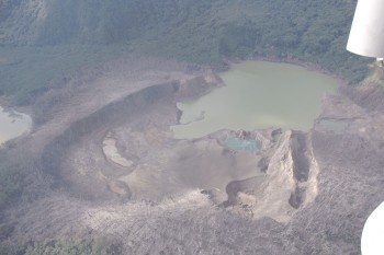
The 21 November 1964 eruption was focused in the Green Lake area; however, discolouration and strong gas upwellings (emissions seen as disturbance of the sea surface) were also noted in Denham Bay. The eruption was preceded by volcanic unrest that included large earthquakes, swarms of smaller earthquakes, 10m’s of water level rise in Green Lake and the outbreak of new hot springs. This eruption formed 12 craters within or near to Green Lake. The eruption was witnessed by meteorological staff and members of the NZ Ornithological (study of birds) Society expedition.
2006
The 17 March 2006 eruption was similar in size and style to the 1964 activity. There was earthquake activity over several days preceding the eruption but no response from the crater lakes. The eruption lasted about 30 minutes rupturing the hydrothermal seal under Green Lake generating phreatic eruptions and forming new craters like in 1964. The regenerating pōhutukawa forest in the area was again devastated. Satellite monitoring data confirmed that the volcano emitted at least 200 tonnes of sulphur dioxide during the eruption. Tragically, a Department of Conservation employee was killed as he was in the crater area at the time of the eruption.
Data: if you are interested in accessing any of the monitoring data from Raoul Island, all of our data is openly and publicly available, and more information can be found on geonet.org.nz. And don’t forget to cite us!
Volcanoes can erupt without warning. We monitor all New Zealand’s active volcanoes for signs of activity and provide updates of activity via Volcanic Activity Bulletins if there are any significant changes to report.
To read more about being prepared for volcanic activity visit the National Emergency Management Agency’s (NEMA’s) website, getready.govt.nz.


