Volcano FAQ
Frequently asked questions about volcanoes.
What do I do in a volcanic eruption?
Please read the advice from the National Emergency Management Agency.
If an eruption were to occur, what are the potential impacts?
Numerous types of hazards may result from a volcanic eruption they include ash falls, ballistic rock falls, cone-sector collapse, pyroclastic flows and surges, debris flows, lava flows and domes, lahars, volcanic gases, volcanic earthquakes, tsunami and seiches, hydrothermal blasts, and atmospheric effects. Many of these phenomena will only affect an area on the volcano or a few kilometres from the volcano. However, volcanic ash fall can be deposited hundreds to thousands of kilometres from its source, making it the product most likely to affect the largest area and greatest number of people. Volcanic ash can seriously affect aircraft that may fly unintentionally through the ash cloud, often many kilometres from the volcano.
There is increased activity on the volcano drums, what does this mean?
The seismometers that we use are very sensitive instruments and can record signals from a variety of sources. The recorded signals or 'trace' on a volcano drum may represent both volcanic and tectonic earthquakes, as well as human-induced or meteorological noise. The pattern of seismicity on a volcano drum can be complex and often difficult to interpret by the layperson.
What do the characters on the top left of a seismic drum or RSAM/SSAM plot mean? For example, what about RATZ/10-HHZ/TP?
This uniquely identifies the seismic site that recorded the trace you are viewing:
- The first part RATZ shows the international seismic station code, in this example 'RA' is an abbreviation for the location of the seismic drum at Rangitukua, 'T' indicates that Rangitukua station belongs within the Taupō seismic network, and 'Z' denotes 'station'.
- The second part 10 shows the location code of the seismometer at Rangitukua. The user can search GeoNet's DELTA database for further information about the geophysical network site; this number corresponds to the location of currently operating instrumentation. Previous location codes and instrumentation is also listed.
- The third part HHZ is defined by the SEED convention, and indicates the characteristics of the seismometer or other sensor in use.
- The fourth part TP shows the network code, in this case 'Taupō'.
What are the strange lights on the volcano webcams?
Most of our volcano webcams have infrared lenses allowing them to "see" at night. The stars and moon are often photographed as lights in the night sky in the correct conditions. Sometimes, reflections from lights on the camera can also cause the appearance of lights on the picture. Strange interferences are usually caused by glare from the sun or moon reflecting on the perspex camera cover, or occasionally from condensation inside the camera housing. Others can be car lights.
What are the locations of the Ruapehu, Ngauruhoe and Taranaki volcano cameras?
We don't publish the exact locations of our cameras for security reasons, although if official groups need their locations for research or response, they can contact us directly.
What do the 'red bits' on the volcano drums mean?
A seismograph is coloured red if it is clipped, i.e. the largest parts of the signal are not shown. If this was not done, then a large earthquake would obscure much of the seismograph from view. In other words, if the signal is red, the real size is larger than is shown on the seismograph.
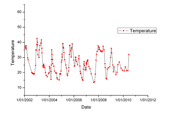
What is the temperature of Ruapehu Volcano Crater Lake?
The temperature of Ruapehu Volcano Crater Lake fluctuates slowly (over weeks to months) in response to pulses of heat rising from deep within the volcano. Recent peak recorded temperatures during a warming cycle have reached almost 40 °C while dropping to less than 15 °C during a cooling period.
Is the Auckland Volcanic Field dormant or extinct? Will Rangitoto erupt again? Where will the next eruption occur?
Auckland City sits on a volcanic field comprised of approximately 50 volcanic cones and craters that erupted at irregular intervals over the past 250,000 years. These volcanoes have formed as a result of intraplate volcanism - this means that there is an active hot spot of magma located approximately 100 kilometres beneath the city. Each time magma rose from the active hot spot it erupted in a new location at the surface. We think that faults might have influenced where magma rose through the crust but there is no successive pattern of where volcanoes have formed, so we cannot predict where a new eruption is most likely to occur. Rangitoto volcano erupted about 600 years ago and is the only volcano in the Auckland Volcanic Field thought to have erupted twice (two eruptions about 50 years apart). However, because it is the only known example of two eruptions occurring from one volcano throughout the entire history of the Auckland Volcanic Field, we think it is unlikely Rangitoto will erupt again.
Are there any volcanoes in the South Island?
Yes, there are many volcanoes and volcanic fields, but none have erupted for several million years. Well-known examples are the Otago (Dunedin) and Banks Peninsula volcanoes which are the eroded remnants of large shield volcanoes that were active around 8 to 20 million years ago, during the Miocene period. There are also Miocene-Pliocene age provinces of intraplate basaltic volcanoes, similar to those in the Auckland Volcanic Field. For example, there are remains of cones and lava flows inland of Dunedin and Oamaru, and in the Timaru-Geraldine area. Much older volcanic lavas and dikes also occur in the South Island.

