Slow slip wakes up
Updated: Thu May 22 2025 2:08 PM
Our instruments are currently picking up a slow-slip earthquake occurring offshore Gisborne. We give an update on what’s happening beneath our feet.
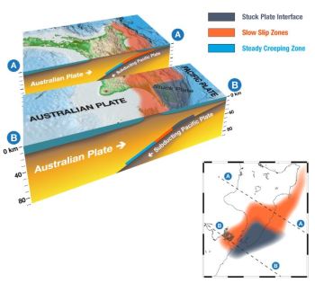
The Hikurangi Subduction Zone – the boundary between the Australian and Pacific plates – extends along Aotearoa New Zealand’s east coast and dives westward underneath the North Island. We frequently identify slow-slip events here.
What are Slow Slip Earthquakes?
Slow Slip Earthquakes (SSE) are like earthquakes in slow motion, unfolding over weeks to months. They are detected by the network of continuously operating Global Navigation Satellite System (GNSS) stations (commonly referred to as GPS) that track millimetre-level movement of the land on a daily basis.
As this release of energy takes place slowly, over a period of weeks rather than seconds, it does not cause shaking that is able to be detected by our seismographs, or people. Instead, it is our continuously operating GNSS instruments, that allow us to see events like this unfold. We often see slow slip events in the Mahia and Hawke's Bay area, with the last event that we reported on in June last year.
When slow slip events occur, they relieve a lot of pent-up stress on the subduction plate boundary. At the same time, they can increase stress on other nearby portions of the plate boundary. So, they can occasionally trigger sequences of smaller earthquakes that may be felt by the public.
Gisborne SSE
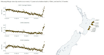
The most recent SSE started around the beginning of December. Continuously operating GNSS stations just north of the Mahia Peninsula moved by approximately 4 cm eastwards and 1 cm southwards over the past three weeks, with a few centimetres of displacements observed on stations between Wairoa and Tolaga Bay. To put this in perspective, 5-8cm of movement represents one to two years’ worth of plate motion taking place in only three weeks.
View: Slow Sip watch via our GNSS instruments
Read: Hawkes Bay Slow-Slip earthquake, June 2023
Watch: What is a slow slip earthquake?
Researching SSE
Given the regularity of slow slip events, this region is a prime target for New Zealand and global research efforts into slow slip occurrence and subduction zone processes. Scientists have been deploying additional sensors offshore annually to study these events for nearly a decade! The ability to place instruments on the seafloor enables scientists to record data directly above where the slip occurs. There is currently a dense deployment of around 50 offshore sensors capturing geodetic, seismic, and oceanographic data as part of an international collaboration between researchers in New Zealand, Germany, Japan, and the United States. This remarkable offshore deployment will help us map the spatial extent of the slow slip event, any related seismicity, and will be used to improve our understanding of the subduction zone in general as data are collected and utilised in the coming years.
Our team will continue to keep an eye on this slow slip activity during the holiday season, and we will have more in-depth information on this event in the new year.
Slow-slip events are a great reminder that we Kiwis live on a very active tectonic plate boundary!
In the event of a large earthquake: Drop, Cover and Hold.
Remember Long or Strong, Get Gone: If you are near the coast and feel a strong earthquake that makes it hard to stand up OR a weak rolling earthquake that lasts a minute or more move immediately to the nearest high ground or as far inland as you can, out of tsunami evacuation zones.
Know what to do?
The National Emergency Management Agency (NEMA) has a great website with information on what to do before, during and after an earthquake.
Prepare your home. Protect your whānau.
There’s a lot we can do to make our homes safer and stronger for natural hazards. Natural Hazards Commission Toka Tū Ake's website has key steps to get you started.
Media Contact: 021 574 541 or media@gns.cri.nz
This SSE was originally reported as in the Hawkes Bay region, and has now been edited to its correct Gisborne location.


