In memory of FITS
Welcome, haere mai to another GeoNet Data Blog. Today’s blog is an obituary to the FITS API and database, which was turned off last week after 10 years of glorious service. Although the format is a little different from our usual blogs, we thought it an appropriate way to remember an application that provided long-standing service to GeoNet, and helped grow a culture change.
FITS
Field Time Series (FITS), 10 years of age, of GeoNet Amazon Web Services (AWS) cloud, passed away on 10 April 2025. Survived by Tilde. Remembered fondly as a groundbreaking application in the GeoNet family, FITS will be remembered at a private service at GNS Science in Avalon.
Biography
The Beginning
FITS first went live in 2015, but it’s conception dates back to 2014. While GeoNet had applications for seismic data, we had no means to deliver lower rate time series data in a way that was both efficient and practical. Foremost among the data needing a delivery application was GNSS daily positions solutions, and not far behind was a diverse range of volcano monitoring data.
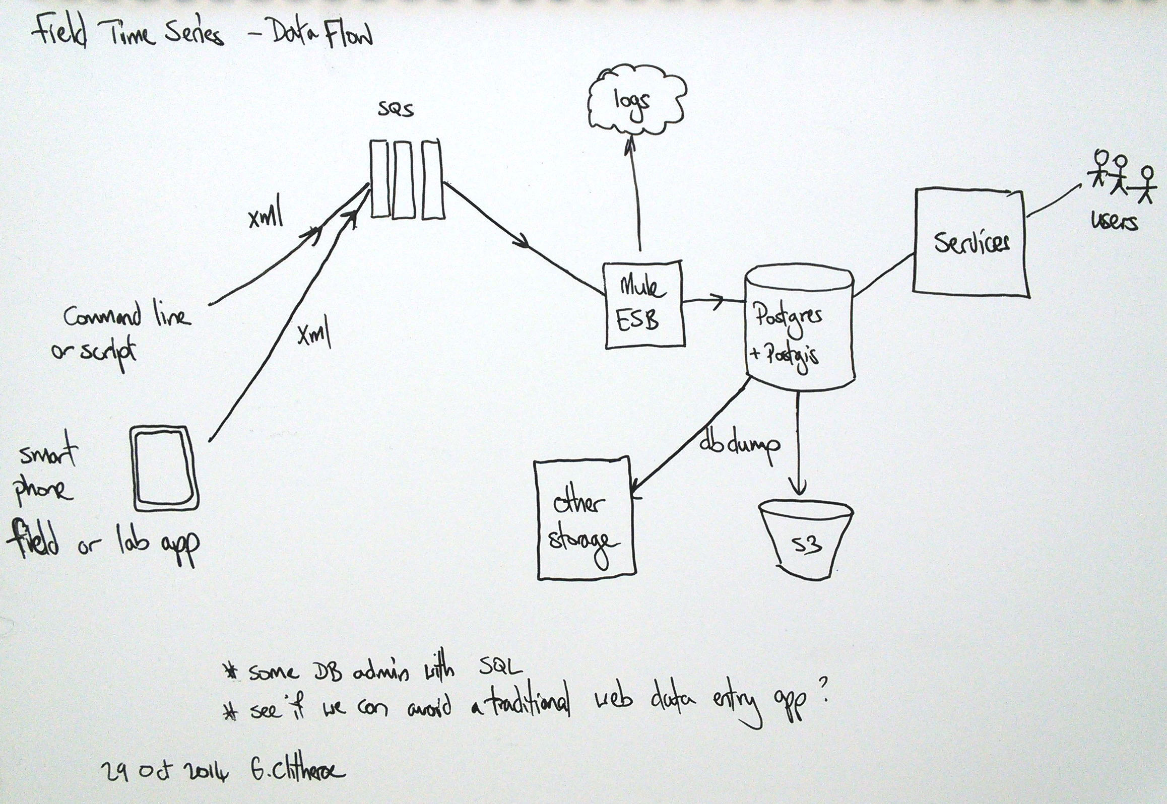
An early planning stage sketch of the data flow for FITS.
The early years
At its core, FITS provided a typical Application Program Interface (API) for data retrieval in JSON and CSV formats. What was a little unusual was in having an API option to provide graphs of data. The FITS plotting function was lauded for its simplicity, practicality and speed of response, while at the same time being criticised for its lack of flexibility. Although the plots were not really suitable for sharing in presentations, the ease with which they could be created and shared meant that many scientists used them when giving talks.
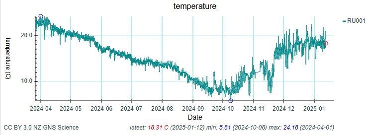
A basic FITS graph retrieved directly from the API. Not really ideal for sharing externally, but many did due to how easily graphs like this could be produced.
The plotting functionality proved to be an ideal platform for displaying GNSS daily position solutions. The plotting code was reused in a special website page on slow-slip events, that was used several times in news stories.
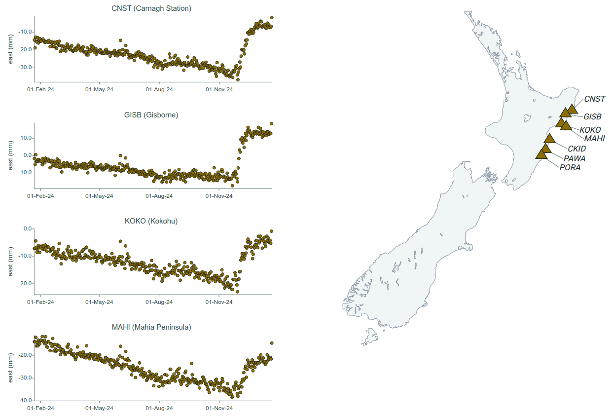
This Slow Slip Watch page retrieved data from FITS and reused plotting code behind the FITS API. With the data now available through Tilde, the backend code has changed, but the graphing is similar, and our data community gets a very similar view.
Volcano data also embraced FITS. The diversity of volcano data meant many different parameters and values. FITS’s database schema hadn’t envisaged all the quirks of various volcano data, and some adaptations in the data were required, but overall FITS did a great job.
Mid-life
By the time FITS was a few years old its active development stopped, and emphasis switched to maintenance. FITS still led an active and fulfilling life. Newly processed GNSS daily position data were added daily, and volcano data of many types on a regular basis.
The later years
In later years, FITS’s limitations became more obvious. As an older piece of computer code, FITS wasn’t written in the same way as GeoNet’s newer applications. While a substantial re-write was considered, the best option was a complete replacement, with what became Tilde. From that point, FITS’s days were numbered. Once Tilde was up and running, datasets were progressively transferred from FITS, and a lot of data that were never in FITS were also added to Tilde. By early-2025, we were down to the last few datasets. When GNSS daily positions solutions, FITS’s first dataset, moved to Tilde in February 2025, and we tidied up some volcano data, that was the end. FITS passed away quietly on 10 April 2025.
The legacy
Although FITS is gone, it has an important legacy in GeoNet data delivery. GNSS daily position solutions are widely used by our science community (particularly those not wanting to process raw GNSS data themselves, a complex and time-consuming process) and delivering those was something it did with great success for a decade. It’s contribution to volcano data was perhaps even greater. Before FITS there was no means of making any low-rate volcano data available to our data community. They had to simply know the data existed and ask someone for a copy. Not always the best solution. Almost single-handedly, FITS changed volcano data culture at GeoNet.
That’s it for now
If you used to use FITS for GeoNet data, we hope that by now that you realise Tilde is the place you should now look for those data. If you have any questions about Tilde or retrieving and using data, we have Data Discovery and Data Exploration GUIs, and extensive tutorials for those who work with computer code, but if none of those solve your problems you can always ask us. You can find our earlier blog posts through the News section on our web page just select the Data Blog filter before hitting the Search button. We welcome your feedback on our data blogs and if there are any GeoNet data topics you’d like us to talk about please let us know! Ngā mihi nui.
Contact: info@geonet.org.nz