Whakaari/White Island plume a showstopper in clear skies
People in the Bay of Plenty, and visitors to our volcano cameras page may have spotted an almost continuous steam and gas plume from Whakaari/White Island recently.
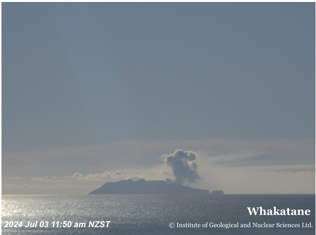
This image captured on Wednesday 3 July shows the plume of gas and water vapour drifting eastwards from Whakaari White Island.
What causes a gas and steam volcanic plume?
With ideal weather conditions over the past couple of weeks, residents of the Bay of Plenty coast could see a large steam and gas plume from Whakaari/White Island. These were also visible via our camera watching the volcano from Whakatane.
The plume originates from several active vents inside the main crater on the island, including the vent that generated the weak eruptions during May this year.
Volcanic plumes are emitted when steam, gas, and sometimes ash is released at the surface of the volcano. When the volcano is not erupting, volcanic plumes can still be created, but little to no ash may be present. We refer to these non-eruptive, passive plumes – like the one we have seen over the past weeks – as a “steam and gas” plume.
Many factors contribute to the appearance of the steam and gas plume, including heat flow, gas output, and the presence of ground water, lakelets or crater lakes. Atmospheric humidity, dew point, air temperature and windspeed can also play a role in how they appear above the volcano. Just like in winter when we breathe outside in the cold air, when all of these factors line up it can result in spectacular looking plumes like we have seen rising from the volcano recently.
What drives this?
As molten rock (magma) rises under the volcano the pressure drops and volcanic gases leak from the magma. This starts deep under the volcano. As the gas can travel more easily through the volcano than the magma it soon makes its way to the surface, to vent and form a plume above the volcano.
A steam and gas plume is about 80 percent steam and water vapour (H2O). After steam, in order of volume, the gases are carbon dioxide (CO2), sulphur dioxide (SO2) and hydrogen sulphide (H2S). GNS measures the volume of gases present during regular gas and observation monitoring flights.
What about volcanic ash?
Our Volcano Activity Bulletin published on 16 July advised that minor amounts of ash were observed intermittently at the vent during a recent gas flight. This was not considered to constitute new eruptive activity. Instead, the small amount of ash observed was likely caused by some erosion inside the vent due to the vigorous degassing that was feeding the steam and gas plume. These kinds of changes in the vent area and the plume have been seen many times in the past and represent normal processes at the volcano. No ash was observed in the plume outside of the crater.
How far from the mainland is Whakaari/White Island?
Whakaari/White Island sits 48km offshore from Whakatane, on the North Island of New Zealand.
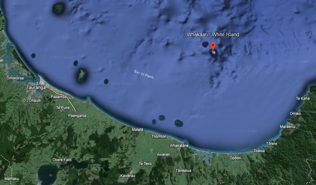
Whakaari/White Island location
What does it look like underwater?
Whakaari/White Island is a very large volcano, similar in scale to Tongariro. About 70 percent of the volcano is under the sea.

Whakaari/White Island size comparison
What are the impacts of a plume?
Due to Whakaari/White Island’s distance from the North Island coast, and the prevailing wind that takes the plume away from the coast, there is a very low likelihood of it having any effect on the mainland. However, plumes have reached the mainland before and records exist of plumes reaching the coast dating back to at least 1873.
The most likely, albeit infrequent, impact of a plume such as the one we are seeing now is that people might smell volcanic gas and possibly find it an irritant to the eyes and respiratory system. With the current activity taking place far from the coast, and with no ash in the plume, this is unlikely. Neither do we expect ashfall on the mainland with the current state of activity. Should the volcanic activity increase, people would be provided with appropriate advice to manage any hazard effects.
What do New Zealand’s Volcanic Alert Levels mean?
At the time of publishing this story Whakaari White Island is at Volcanic Alert Level 2 – which means it is in a moderate to heightened state of unrest.
To help us communicate the current status of the active volcanoes in New Zealand, we use the New Zealand Volcanic Alert Level System. This system defines the current level of activity at each active volcano. The alert levels range from 0 to 5, where level 0 is no volcanic unrest and Level 5 is a major volcanic eruption.
The Alert Level itself is a simple method of indicating a status change in the volcano. We use Volcano Activity Bulletins to communicate in-depth and important information about the activity and trends occurring at the volcano. The bulletins are shared with local and national responding agencies, stakeholders, media and the public.
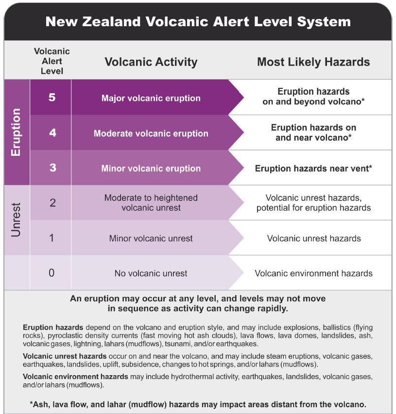
New Zealand Volcanic Alert Level System
Does Volcanic Alert Level 2 mean the volcano will erupt?
The NZ Volcanic Alert system is not a predictive tool. It reports the current state of the volcano, and the level of unrest could be increasing towards an eruption or declining after one. Level 1 and Level 2 communicate periods of volcanic unrest. Levels 3, 4 and 5 relate to small, medium/moderate and large eruptions.
On 24 May 2024 we raised the Volcanic Alert Level to 3 following minor and short-lived eruptive activity and lowered it back to Level 2 on 29 May when the eruption stopped. However, there have also been times recently that Whakaari/White Island has remained at Level 2 unrest and no subsequent eruptions happened.
It’s important to note that an eruption might occur at any alert level, and volcanic alert levels do not necessarily move in sequence as activity can change rapidly.
Due to Whakaari/White Island’s distance from the North Island coast there is an extremely low likelihood of any effects from an eruption on the mainland. If there were any effects, the most likely are fine ash falls (like pollen or talcum powder) and the smell of volcanic gas.
How do you keep watch on Whakaari / White Island?
At present, the Volcanic Ash Advisory Centre at MetService provides most of the ability to confirm if larger ash producing eruptions have occurred, via satellite remote sensing and rain radar data.
Our combined remote monitoring toolkit includes monitoring stations on the mainland, observation and gas flights, and remote sensing technology, like radar, gas, and thermal satellite imagery. We also receive information about Whakaari from satellite data from the German and European Space Agencies, which can provide us a view of ground deformation and gas emissions.
Where to go for advice
Head to the Bay of Plenty Civil Defence website for specific local advice for the Bay of Plenty
Advice on preparing for ash fall and what to do if it has fallen in your area from the U.S. Geological Survey
Guidelines on public health in relation to volcanic unrest and eruptions from the International Volcanic Health Hazard Network