
From earthquakes to eruptions, a look back at 2024
We take a quick look back at the happenings and highlights observed by GeoNet in 2024.
Earthquakes
In 2024 22,904 earthquakes were located around New Zealand and in the Kermadec region, the largest was a M5.9 115 km east of Te Araroa, on Nov 28. And the most felt earthquake was a M5.7 earthquake 25km west of Wellington on Oct 6th, with over 37,000 reports submitted.
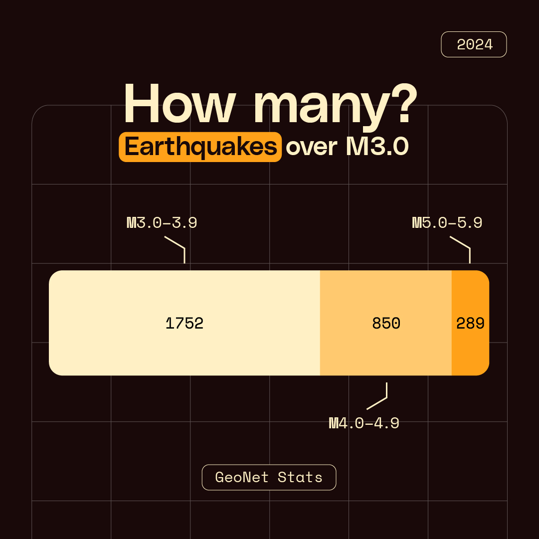
Breakdown of 2024 earthquake sizes
A sequence of 10 earthquakes, within a week in June, between magnitude 1.2 and 3.5 were recorded south-west of Christchurch. These were within the expected behaviour for the 2010 Canterbury aftershock sequence.
So, is that a lot of earthquakes for one year? It’s actually pretty spot on!
On average, we locate over 20,000 earthquakes a year through the National Geohazard Monitoring Centre. In 2023 we located 21,300, with around 100-150 of these quakes being large enough to be felt by people. The others we only know about because they are recorded by our network of sensors.
So why do we get so many earthquakes? Watch our video below and find out!
Volcanoes
2024 was a busy year for our active volcanoes, we published 33 Volcanic Activity Bulletins (24 for Whakaari/White Island activity and 9 for Ruapehu).
Volcanic unrest at Ruapehu was dominated by a cooling lake with the temperature falling from 30 C to 8 C during the year. The lake is now heating and around 19C. The Volcanic Alert Level remains at 1.
In May 2024, a new eruptive episode began at Whakaari/White Island after relative calm since 2019. The crater lake was removed by evaporation and new craterlets/vents were formed in July and August. Steam, gas and ash plumes were widely observed from the coast. The Volcanic Alert Level is now back at Volcanic Alert Level 2.
Read: Volcanic Activity Bulletins
Read: Your questions answered – Whakaari/White Island
Tsunamis
One tsunami was recorded by our instruments in 2024, the M7.3 Vanuatu earthquake on December 17th. This destructive earthquake collapsed buildings Port Vila and neighbouring areas, and unfortunately caused loss of life. The earthquake triggered a small tsunami that was picked up by two of the DART network located close to Vanuatu, and some of our local coastal gauges.
2004 marked 20 years since the M9.2 earthquake in the Indian Ocean that caused a devastating tsunami that tragically claimed the lives of around 230,000 people and affected 14 countries.
Read: The 2004 Indian Ocean Tsunami shocked the world – are we better prepared 20 years on?
Landslides
Following the severe landslide that struck the Enga Province in Papua New Guinea on 24 May 2024, our team of landslide experts supported the Papua New Guinea national geohazards division response remotely from New Zealand.
Read: International landslide collaboration aims to save lives and livelihoods
Network
In 2024 we deployed nearly 1000 pieces of equipment and commissioned 13 new stations to the extensive network across Aotearoa New Zealand.
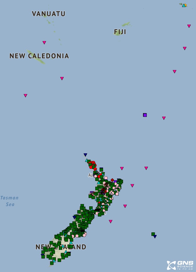
Map of our sensor networks
Explore: Our sensor map
Data
Our data archive grew to more than 330TB in 2024, up from 280TB in 2023. You can access it all through the Registry of Open Data on Amazon Web Services.
Read: Using GeoNet’s AWS Open Data
Read: The importance of sharing GeoNet data - our data blogs.
Website
Geomagnetic data was added to our website displaying real-time data from our two magnetometers located north-west of Christchurch, through a new dashboard. This tool helps us monitor Space Weather events arriving in New Zealand. We can identify the onset of a geomagnetic storm, how it evolves and when it ends.
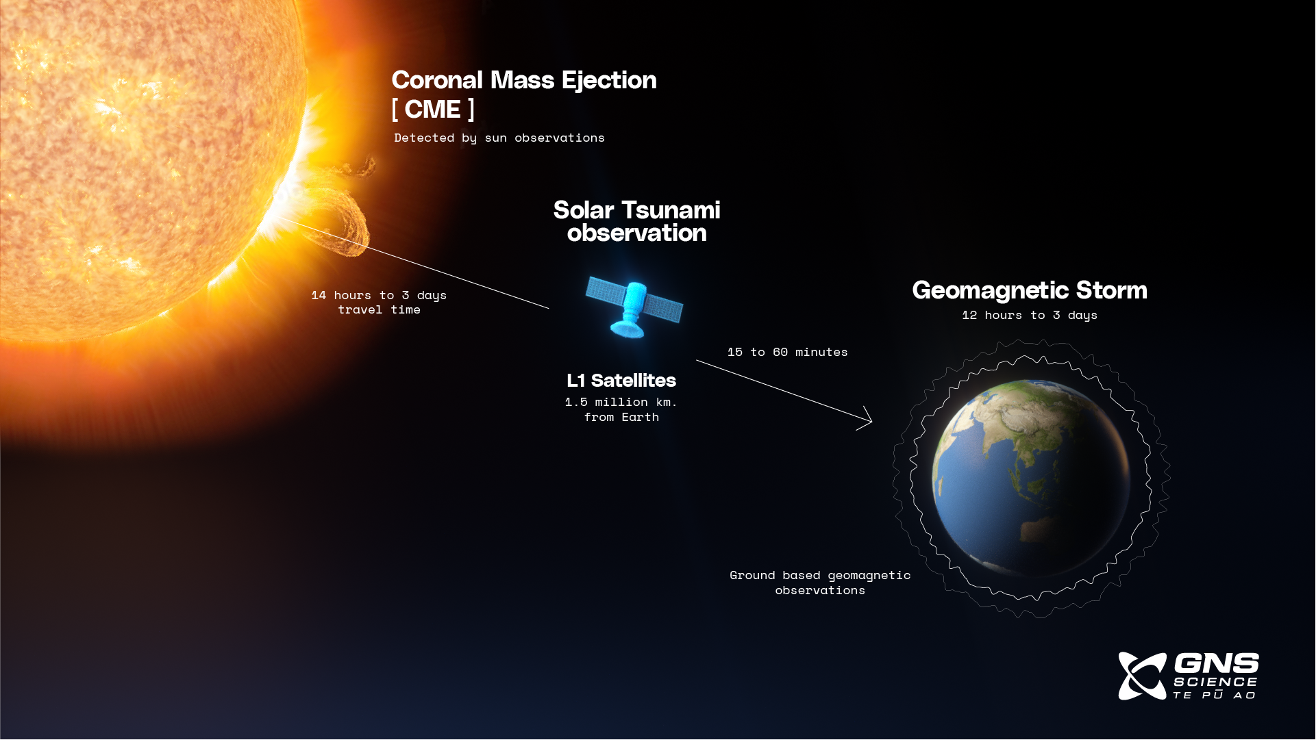
Travel time for coronal mass ejection (CMEs) from the sun to earth.
Read: Space weather and geomagnetic data
Explore: Our Geomagnetic Dashboard
GeoNet App
Over 261,821 users have the GeoNet app on their devices. Our GeoNet App details all earthquakes located in and around New Zealand within a few minutes of their occurrence, and you can set up notifications of earthquakes close to your current location (using your phones GPS), or for multiple locations and earthquake intensities, around the country. You can also read our latest news and keep updated on volcanic activity.
Download: GeoNet Quake for iOS
Download: GeoNet Quake for Android
Are you prepared?
For information on preparing for hazards such as earthquakes, tsunami, landslides and volcanic activity, there are guidelines from the National Emergency Management Agency's Get Ready website.
Prepare your home. Protect your whānau.
There's a lot you can do to make your home safer and stronger for natural hazards. Every step you take will reduce the impact of a disaster on you and your family, so get started today. Check out the Natural Hazards Commission website on how to get your home, apartment, or rental prepared for a natural disaster.