
Earthquake activity continues at Taupō. M 4.2 event felt locally. Volcanic Alert Level remains at Level 0.
The earthquake sequence beneath Lake Taupō continues, now including a magnitude 4.2 event at 6.36 am on Saturday 10 September 2022 – the largest earthquake in the area to date this year. The earthquake was located on the east side of the lake at a depth of approximately 5 km and was widely felt locally. The Volcanic Alert Level for Taupō Volcanic Centre remains at Level 0.
The earthquake sequence beneath the central part of Lake Taupō (Taupō-nui-a-Tia), that we reported on in our previous two Volcanic Activity Bulletins, has continued at a rate of ~40-50 earthquakes per week. Since the start of the sequence in May 2022 the rate has increased from 30 events per week to more than 40 per week. We have now located over 650 earthquakes at less than 30 km depth.
The M 4.2 earthquake on Saturday morning is the largest event this year at Taupō. It was reported felt by 1242 people. The next two largest earthquakes were both magnitude 3.6; the first was recorded on 17 May and the other on 11 July 2022. Since 2000 we have located 7 earthquakes larger than magnitude 4 under the lake, the largest was a M 5.0 on 4 September 2019 located near Motutaiko Island. Saturday’s earthquake was 8 km to the northeast of that 2019 earthquake.
Figure 1 shows that earthquake locations in this year’s sequence are forming three clusters in the central part of the lake. There is a smaller, western cluster centred just offshore from Karangahape Cliffs, then a cluster in the central lake area and the larger eastern cluster that partly wraps around the central cluster. Figure 1 also shows clusters of small earthquakes at geothermal fields in the Taupo area. The magnitudes and numbers of events in the clusters are typical of the ongoing pattern of seismicity. Shown in Figure 2 is the number of earthquakes detected and located each year since 2000 in the dashed area outlined in the map.

Figure 1: Earthquakes located by GeoNet in the Lake Taupō area from January 1 to September 12, 2022. All earthquakes shown here were located less than 30 km deep. There are over 650 earthquakes shown on the ma
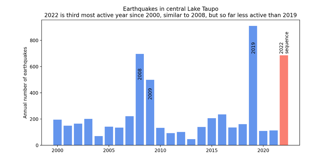
Figure 2: Earthquakes detected and located in the dashed area outlined in the map each year since 2000. The 2022 sequence of earthquakes stands out, at this stage numbers exceed sequences in 2009, are near equal to those in 2008, and remain less than those in 2019.
In addition to seismic activity, GeoNet continuously monitors ground deformation about Taupō. Further to the 12 mm uplift seen from lake levelling data, deformation data from GNSS (GPS) instruments around the lake also show a signal indicating horizontal deformation. Numerical modelling indicates that the horizontal extension is consistent with a deformation source within the main region of seismic activity.
Taupō Volcanic Centre is part of the Taupō Volcanic Zone, a tectonically very active region with many known faults and active volcanism. Activity in this region is often related to a mix of regional deformation processes and the separate magmatic systems under the volcanoes, which has helped to inform our view that Volcanic Alert Level 0 is currently appropriate for the Taupō Volcanic Centre. Therefore, the Volcanic Alert Level remains at 0.
The Volcanic Alert Level reflects the current level of volcanic unrest or activity and is not a forecast of future activity. Volcanic Alert Level 0 indicates the primary hazards are volcanic environmental hazards that may include hydrothermal activity, earthquakes, landslides, and/or volcanic gases. Further information about the Volcanic Alert Levels and what they mean can be found here.
Taupō is an active volcano and earthquakes, and uplift or subsidence will continue to occur in the future. GNS Science through the GeoNet programme continually monitors Taupō and our other active volcanoes for signs of activity.
Although we can’t prevent natural hazards, we can prepare for them – and we should.
For information on preparing for earthquakes or responding to volcanic activity, there are guidelines from the National Emergency Management Agency's Get Ready website.
Toka Tū Ake EQC have information for preparing your home for natural hazards.
Find out more about Taupō Volcano
How do we monitor our volcanoes?
Earthquakes can occur anywhere in New Zealand at any time. In the event of a large earthquake: Drop, Cover and Hold.
Mike Rosenberg Duty Volcanologist
Media Contact: 021 574541 or media@gns.cri.nz