Update from gas flight: volcanic gas emissions increase with minor ash emissions continuing. Volcanic Alert Level remains at Level 3 and Aviation Colour Code remains at Orange.
A gas flight on Wednesday (14 Aug 2024) has confirmed an increase in the amount of volcanic gas being emitted from Whakaari/White Island and that the plumes come from a new source vent. Satellite data also suggests a modest increase in the amount of volcanic ash in the plume since last Friday (9 Aug) compared to the beginning of the eruptive activity in May 2024. There is a very low likelihood of ash impacting the mainland.
The Volcanic Alert Level remains at Level 3 (minor eruption) and the Aviation Colour Code remains at Orange.
During our gas flight on Wednesday, we measured a large increase in the amount of volcanic gases being emitted from the new active vent since our last gas flight on 18 July (Fig. 1). Minor amounts of volcanic ash were also observed in the plume, downwind from the island (Fig. 2). The gas and ash are being emitted from a vent about 10–15 m across. These observations are consistent with the satellite observations from the Wellington Volcanic Ash Advisory Centre (NZ MetService) and our GeoNet webcams at Whakatāne and Te Kaha.
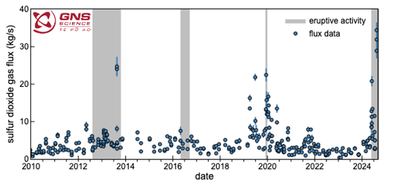
Figure 1. Amount of sulphur dioxide (SO2) gas (blue circles) emitted since January 2010. Periods of eruptive activity are shown by grey bands in the background. SO2 emissions have increased since the volcanic activity increased at the end of May 2024 (grey region to the far right of the plot).
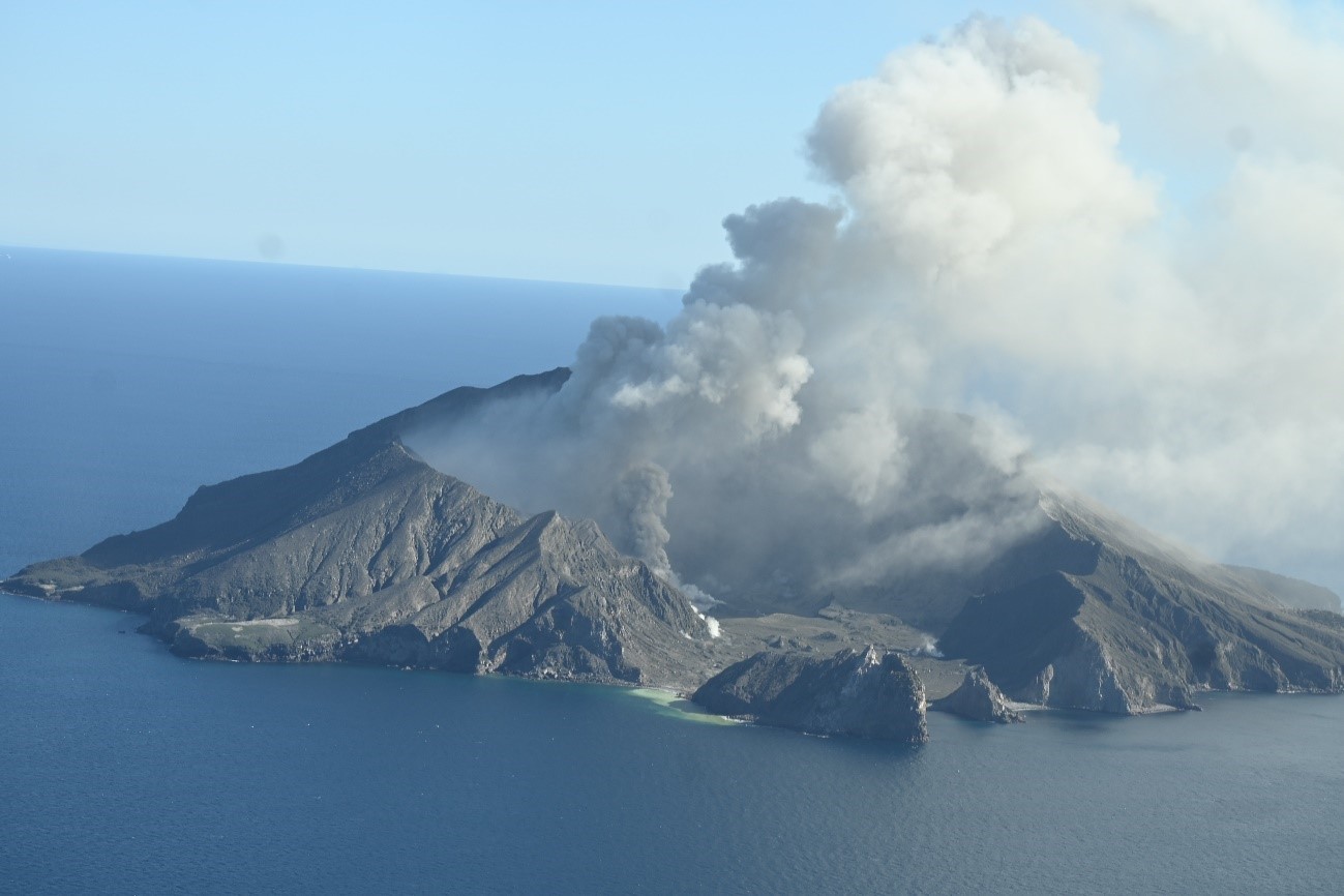
Figure 2. Picture of the minor ash emission from the active vent that is feeding the plume from Whakaari/White Island during Wednesday’s gas flight (14/08/24).
We were also able to obtain a small ash sample during the flight and initial analyses are consistent with it been derived from a shallow magma source.
These new data confirm there has been a change in the eruptive activity from the island since the beginning of August. There is more gas, and more continuous minor entrainment of volcanic ash in the hot plume. This is consistent with magma (molten rock) being close to the surface and driving the activity. This is part of the typical eruptive cycles seen at Whakaari/White Island. Based on past eruptive episodes over the past 30 years, this activity could continue for some time, maybe weeks to months.
NZ MetService has been able to track the volcanic ash in the plume for tens of kilometres from the island over the past week due to clear sky conditions around Whakaari/White Island. Plumes have reached up to 2 kilometres elevation, under calm conditions.
The concentrations of volcanic ash are very low and sometimes difficult to detect. As the weather changes the plume may at times be blown towards the Bay of Plenty coast. However, at the current level of ash emission, there is a very low likelihood of ash impacting the mainland. The level of volcanic activity would have to change significantly for this likelihood to increase.
We will continue to closely monitor volcanic activity at Whakaari with remote cameras, satellite imagery, and regular monitoring flights. We will provide updates when information becomes available.
GNS Science’s National Geohazards Monitoring Centre and Volcano Monitoring Group, through the GeoNet programme, will continue to closely monitor Whakaari/White Island for further changes in unrest.
Further information about the Volcanic Alert Levels and what they mean can be found here.
For information about the impacts of the steam and gas plume or volcanic ash should it reach the coast, follow the advice from:
Ery Hughes (she/her)
Duty Volcanologist
Media contact: 021 574541 or media@gns.cri.nz