Minor volcanic unrest continues at Mt Ruapehu as lake cools. Volcanic Alert Level remains at 1.
Over the last six months at Ruapehu, Te Wai ā-moe (Crater Lake) has slowly cooled from 31 °C to 11 °C. Our volcanic gas monitoring continues to measure low-moderate volcanic gas emissions. The Volcanic Alert Level remains at 1 and the Aviation Colour Code at Green.
Te Wai ā-moe (Crater Lake) temperature continues to slowly decline. Currently the lake temperature is around 11 ºC, down from a peak of 31 ºC on 14 February. The current temperature is one of the coldest recorded in the lake since we started measurements in the 1950s (Figure 1). The amount of sulphur dioxide (SO2) volcanic gas passing through the lake has also declined with the lake temperature. The daily average gas flux from our scanDOAS (Differential Optical Absorption Spectrometry) sensors has fallen from approximately 2 kg/s (172 tonnes per day) in February to about 1 kg/s (86 tonnes per day) this week. The lake water level has been variable, due to rain and/or snow, but is usually around overflow.
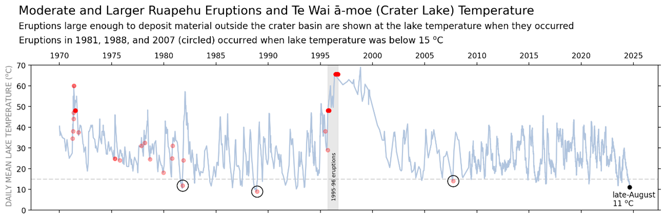
Fig. 1. Temperature of Te Wai ā-moe with moderate-to-large eruptions shown by red dots. When many eruptions occurred close together the dots overlap and appear more intense (black circles highlight eruptions when the lake temperature was below 15 ºC).
The rate of heat input into the lake has also fallen from around 200-250 MW in February to around 50 MW’s now. The cooling of Te Wai ā-moe, together with declining gas flux, is consistent with cooling of the hydrothermal system beneath the lake.
The unusual volcanic earthquakes initially identified in March continued through to June. The occurrence of these uncommon style of small volcanic earthquakes beneath Ruapehu has now ceased. Volcanic tremor levels, generated by fluid and gas flow in the hydrothermal system, have remained low all year.
The temperature of Te Wai ā-moe fluctuates due to semi-regular heating cycles (Figure 1). Research on the eruptive history of Ruapehu has shown that the probability of an eruption increases when the lake is significantly warmer or colder than the median temperature. However, eruptions have been significantly more frequent when the lake was hot rather than cold. Since 1970, 115 eruptions large enough to impact the summit area have occurred, with only three taking place when the lake is cooler than 15 ºC (Figure 1).
Our recent observations are consistent with ongoing, low-level volcanic unrest at Ruapehu. Low lake temperatures and limited gas emissions indicate that the hydrothermal system is partially sealed, restricting heat and gas flow to the surface. We expect a new heating cycle to begin over the coming weeks based on past temperature trends.
Because the hydrothermal system is partially sealed, any new gas and heat flow strong enough to rupture the seal may lead to a small eruption. This has occurred on three previous occasions (1981, 1988, 2007; Fig. 1). However, in the majority of cases, a new heating cycle begins without an eruption. Thus, a sudden eruption at Mt Ruapehu remains very unlikely.
Monitoring indicators remain consistent with a low level of volcanic activity. As a result, the Volcanic Alert Level remains at 1. The Aviation Colour Code remains Green.
More information:
Mt Ruapehu is an active volcano and has the potential to erupt with little or no warning when in a state of minor volcanic unrest.
The Volcanic Alert Level reflects the current level of volcanic unrest. The Volcanic Alert Level should not be used to forecast future activity.
Volcanic Alert Level 1 indicates the primary hazards are those expected during volcanic unrest: steam discharge, volcanic gas, earthquakes, landslides, and hydrothermal activity. While Volcanic Alert Level 1 is mostly associated with environmental hazards, potential for eruption hazards also exists and eruptions can still occur with little or no warning. Volcanic Alert Levels 3, 4 and 5 are reserved for eruptions with varying impact distances.
For information on access to the Mt Ruapehu area, please visit the Department of Conservation’s website on volcanic risk in Tongariro National Park and follow the DOC Tongariro Facebook page for further updates.
For information about responding to volcanic activity there are guidelines from the National Emergency Management Agency here.
GNS Science and its National Geohazards Monitoring Centre continue to closely monitor Mt Ruapehu for further changes.
Paul Jarvis
Duty Volcanologist
Media Contact: 021 574 541 or media@gns.cri.nz