Low level eruption continues with variable gas and ash emissions at Whakaari/White Island. Volcanic Alert Level remains at Level 3 and Aviation Colour Code at Orange.
Images from GeoNet cameras and satellite imagery combined with data from gas-measurement flights on the 5th and 11th of September 2024, confirm that minor eruptive activity Whakaari/White Island continues.
Gas flux data from the September 5th flight point to some of the highest measured sulphur dioxide (SO2) emissions in the last 20 years. However, data from the 11th show a decrease which is consistent with other observations of the plume. Taking these variations into consideration, the total gas output from the volcano remains higher than normal.
Observations from yesterday’s flight show the vent area has enlarged slightly and the emissions are now more variable. On Wednesday 11th the GeoNet camera images showed a higher and darker plume, suggesting that the amount of volcanic ash had increased substantially, while this morning the images indicate a lot less ash is present. The plumes have been rising to a few hundred metres above the volcano before being dispersed tens of kilometres downwind by local winds. Although the plume sometimes reached a kilometre above the island, the ash from it has been falling only within 1 – 3 km of the island and the likelihood of ash fallout on the mainland remains very low. The Volcanic Alert Level remains at Level 3 (minor eruption) and the Aviation Colour Code remains at Orange.
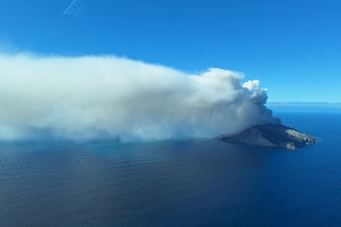
Image of the gas and ash plume at Whakaari White Island on 5 September 2024. Ash fall from the plume was only noted near the island. Credit A Mazot.
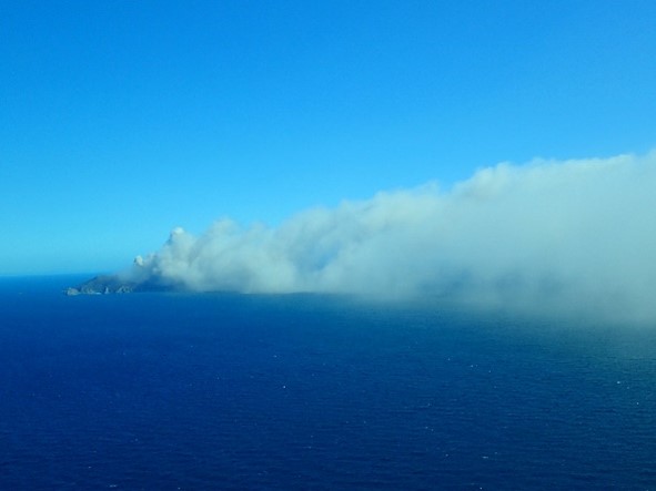
Image of the gas and ash plume at Whakaari White Island on 5 September 2024. Ash fall from the plume was only noted near the island. Credit K Britten.
With clear views, GeoNet cameras at Whakatāne and Te Kaha have showed a continuous volcanic plume and using satellite imagery, NZ MetService have tracked the plume for tens to over 100 kilometres downwind of the volcano. Under some conditions the plume has passed over the land.
Our observations and data indicate small changes in the eruptive activity have occurred over the last 7-10 days. Strong emission of volcanic gases with small amounts of ash continues and is variable through time. The vent area changed shape sometime between the 5th and 11th of this month. Our observations and the high emissions of hot gas, indicate magma (molten rock) remains likely to be close to the surface and releasing its gases with some minor amount of volcanic ash. Although the vent area has changed slightly and the amount of gas and ash varies through time, the ongoing eruption broadly appears to be of small size and quite steady. The size of the ash grains sampled on September 5th and 11th flights was measured at between 0.005 mm and 0.05 mm (5 to 50 thousandths of a millimetre) in size.
With changing wind directions, NZ MetService advise us and the aviation industry that there is sometimes a chance that the plume will be blown towards the Bay of Plenty and East Cape coast. Consequently, there have been some precautionary disruptions to flights. People living in the coastal regions might notice a slight sulphur smell from the volcano plume when winds blow the plume inland. Currently, the small amount of ash carried in the plume and its very fine grain size, means there is a very low likelihood of ash falling to the ground in coastal areas of the north island. The level of volcanic activity would have to escalate significantly for this likelihood to increase.
GNS Science’s Volcano Monitoring Group and National Geohazards Monitoring Centre will continue to closely monitor volcanic activity at Whakaari with remote cameras, satellite imagery, and regular monitoring flights. We will provide updates when information becomes available.
Further information about the Volcanic Alert Levels and what they mean can be found here.
For information about the impacts of the steam and gas plume or volcanic ash should it reach the coast, follow the advice from:
Michael Rosenberg
Duty Volcanologist
Media contact: 021 574541 or media@gns.cri.nz